With the “bisses” as your guide
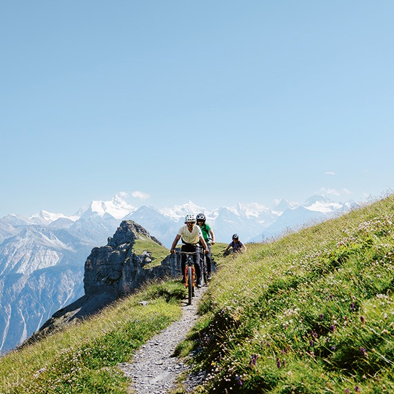
Hiking amongst the Alpine flowers
Running along the Alpine fields and forests, these traditional irrigation channels — which carry glacial waters to the cultivated vineyards and orchards below — have become a breadcrumb trail for beautiful (and occasionally vertigo-inducing) strolls.
The word is obvious to anyone from Valais or French-speaking Switzerland, but not all French speakers: a “bisse”. In other words, a narrow irrigation canal that was carved out of the Alpine cliffsides centuries ago to deliver water and fill the drinking troughs below. Occasionally, they even run along cliffsides and pass through tunnels to bypass natural obstacles or travel from one valley to another. Today the bisses are still an essential part of local agriculture — there’s 1,800 km of them in Valais alone! — but they also serve a more poetic purpose: guiding hikers across nostalgic, and sometimes acrobatic, walking trails.
The spectacular Bisse du Ro
If we could only mention one, this would be it: the Bisse du Ro. Originally built in the 14th century, the canal’s upper section was replaced in the 1940s with a tunnel that runs beneath Mont Lechaux. The canal was restored with the help of heritage specialists and partially refilled with water in 2015. Today it is the heart and soul of a beautiful, marked walking trail, which is well maintained but highly elevated in one section.
It begins in a place known as “Plans Mayens”, unless you prefer to start at the other end at the Tseuzier Dam (1,778 m), which is accessible by car from late June to early November. One direction is 440 m in ascending elevation and 160 m descending (3.5-4 hours); the other is bit less strenuous (2.5-3.5 hours), but either way you’ll cover 12 km.
Accompanied by the babble of running water as it rushes over stones and wooden gutters, the pathway from Plans Mayens rises and falls as it passes through the pine trees. On one side looms a mossy cliffside, which forces hikers at times to contort themselves along the cliffside’s rocky awnings to pass. On the other side: a steep drop, which peeks out from behind the tree trunks. While not unconquerable, it does feel a bit like tiptoeing across a never-ending balcony — with a wooden handrail that’s available when needed, of course!
Above you small waterfalls drift into view, with a rush of mist and flowing water that’s music to your ears. The path narrows further, until you almost feel like you’re walking on thin air, until the halfway point when you reach the 124-metre-long Bisse du Ro hanging metal footbridge, which crosses a canyon at 70 metres high. A few more vertigo-inducing moments await amongst the waterfalls and scree, with a few slender ropes for comfort, and then another 1.5 hours of walking through a sparse forest, until you reach the magnificent Tseuzier Dam, surrounded by mountains and clouds.
Waterfalls and panoramas: the Bisse du Tsittoret
Slightly more recent (15th century), the discreet yet lively Bisse du Tsittoret carries water from the Tièche River to the hamlet of Colombire and beyond. Here you can expect larch forests, beautiful waterfalls, wooden steps, a delicious stop at the Cave du Sex snack bar (known for its cheese), and — if you’re lucky — fantastic panoramic views of the imperial mountain peaks on the other side of the valley: the Weisshorn, Zinalrothorn, Ober Gabelhorn, Matterhorn, and Dent Blanche. Route options abound: a simple climb to the waterfalls from Colombire and back (2 hrs), the complete route starting in Vermala and descending towards Aminona (3-4 hrs), or a full day trip along the winding, rocky ascent of Trubelstock (2,998 m) via the Col de la Roue mountain pass.